CLZK 26,3 km - CROSS LOZORNO
REMOTE CORNER
Presentation
25/05/2025 at the start in Lozorno – Abeland 08:00 AM – 09:00 AM
CLZK start and starting fee
25/05/2025 at 10:00 AM at the start in Lozorno – Abeland
Price incl. VAT: EUR 35
Finish
The race is a circuit with its start and finish in Abeland, Lozorno.
Cut-off time
The cut-off time in the finish in Abeland is at 3:00 PM.
The cut-off time at the Červený domček aid station is 3:30 after the start. Thereafter, starting numbers of the runners will be revoked and they will thus be excluded from the race.
Expected finish of the winners of CLZK 26.3 km
First man at 12:10 PM, first woman at 12:35 PM
CLZK 26.3 km categories
M / M 40 W / W 35
To classify a runner into the age category, his/her age reached in this year is decisive regardless of the day and month of birth.
Trail
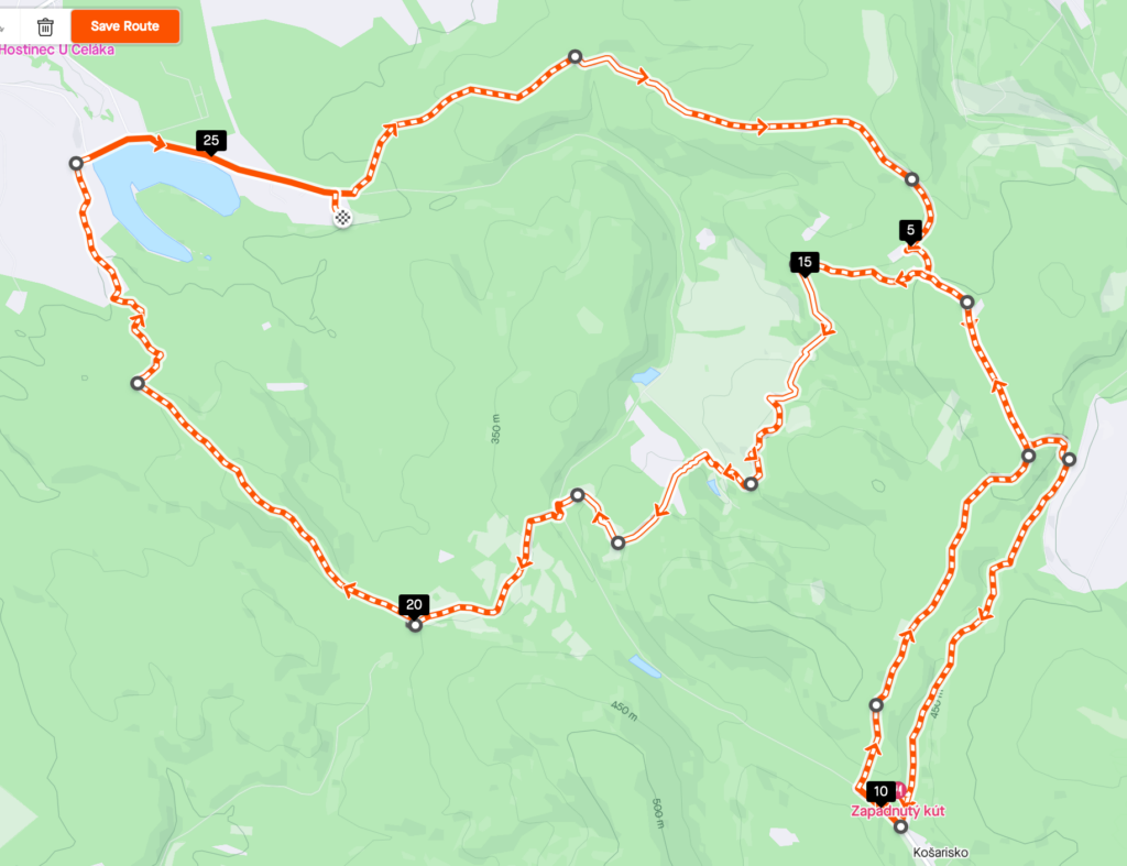
The trail starts with massed start in the Abeland farm village behind the Lozorno dam. A short section is on an asphalt road with the limited traffic (circa 300 m}. After 300 m on the asphalt road, turn left to the yellow mark. Here the trail starts to ascend in the section of 4 km. The trail goes beside the locations Lozornianske breziny, 324 m above the sea level, and Na vŕškoch, 380 m above the sea level, almost up to Lipy, 472 m above the sea level. It continues along the contour line following the newly marked yellow mark (avoiding the military territory) towards Skala, 502 m above the sea level. There is a checkpoint with the aid station located at Skala next to the steel Slovak double cross with the inscription MILENIUM 2000. From Skala, follow the blue mark on the forest road. Leave the forest road behind and, still following the blue mark, reach Prepadlé after a steep rundown, where you’ll join the green mark. The second aid station with the Zapadnutý kút checkpoint are situated there on the 10th km. From there, a short steep runup using the asphalt road back to the forest, the second visit to Skala, 502 m above the sea level, where you will be checked for the second time and can have a refreshment (14.28 km from the start). After a steep, more demanding rundown, the trail turns left for another uphill next to Chov koní (Horse Breeding) with the views towards meadows and forests of Lozorno. Running down you cross an asphalt road and, after a mild uphill, you join the CLČD 10 km trail at Pri suchom potoku (At the Dried Creek), 360 m above the sea level. From there, the trail continues downhill towards Červený domček, 336 m above the sea level, with the aid station waiting for runners. From Červený domček, the shortly ascending trail continues following the red mark to Ohek, 377 m above the sea level. From Ohek, the trail descends in the section of 1.5 km through the forest to the meadows above the dam with beautiful views towards the village of Lozorno and the dam as such. Less than 2 km on an asphalt road remain to finish the race.
The total length of the trail is 26.3 km with the vertical drop of 800 m.
Map

Profile

REGISTRATION FORM FOR CLZK
The application is considered valid only after payment!


